Amazon Location Service: Enhancing Mapping and Location Capabilities with New APIs
Amazon Location Service has recently expanded its offerings by introducing 17 new and enhanced APIs aimed at improving the Routes, Places, and Maps functionalities. This update seeks to provide developers with a more cohesive and streamlined experience, making location services more accessible and useful across diverse applications. These enhancements are driven by customer feedback, which highlights the need for more detailed APIs and features that cater to specific requirements.
Expanded Features and Capabilities
Amazon has made notable additions to its Amazon Location Service to address the specific needs of its users. Developers can now leverage advanced route optimization, calculate toll costs, snap GPS traces accurately to road networks, and access a variety of map styles with both static and dynamic rendering options. Furthermore, users can perform proximity-based searches and receive predictive suggestions, enriched with detailed information about points of interest.
Routes API Enhancements:
The Routes API has undergone significant improvements to support more advanced route planning and customization options. Key features include:
- CalculateIsolines: This feature helps to identify service areas based on specific travel times or distances, allowing businesses to define service zones.
- OptimizeWaypoints: This tool determines the most efficient sequence of waypoints, minimizing travel time or distance.
- Calculate Toll Costs: Users can now obtain precise cost estimates for routes that include toll roads.
- SnapToRoads: This functionality enables accurate matching of GPS traces by snapping points to the road network, enhancing the precision of location data.
These features allow for the creation of more dynamic and accurate routing experiences, beneficial for industries like logistics, where optimizing driver routes in real-time can lead to cost savings and improved service.
Maps API Enhancements:
The Maps API has been updated with new map styles created by expert cartographers. These styles offer professional designs that accelerate time to market by eliminating the need for custom map creation. The Static Map Image feature allows developers to embed static maps within applications, improving performance in scenarios where map interactivity isn’t necessary.
Key features include:
- GetTile: This function allows the download of a tile from a tileset with specified X, Y, and Z axis values.
- GetStyleDescriptor: Users can retrieve information about map styles, making it easier to maintain visual consistency.
- GetStaticMap: This feature supports the rendering of non-interactive maps for reporting or visualization purposes.
Places API Enhancements:
The Places API now provides more detailed search capabilities, catering to requests for increased granularity in location data. New capabilities include:
- SearchNearby and Autocomplete: These functions support proximity-based queries and predictive text features for improved user experience.
- Enhanced Business Details: Categories such as Business Hours, Contact Information, and additional attributes for points of interest are now available.
These enhancements are crucial for applications requiring detailed information about nearby locations, such as food delivery services or retail applications. For instance, a food delivery app could use SearchNearby to locate restaurants, display business hours and contact information, and utilize OptimizeWaypoints for efficient delivery routes.
Putting Enhanced Location Services into Action
The integration of these new APIs is straightforward. Developers can use the AWS Command Line Interface (CLI), AWS SDKs, or the REST API to call the services. For web or mobile applications, additional setup is necessary for displaying information on a map. Authentication for API calls can be done using AWS Sigv4 or API keys, with the latter recommended for front-end applications where user authentication is not required.
Here’s a practical demonstration of using these APIs:
Step 1: Create an API Key
Using the AWS CLI, developers can create an API key for their applications. This key enables access to the Amazon Location APIs.
Step 2: Get Geographic Coordinates
Using cURL, developers can retrieve geographic coordinates by calling the GeoCode API with an address query. For example, finding the coordinates for the city center of Lille, France, will return precise GPS data.
Step 3: Search for Nearby Places
With the coordinates obtained, developers can use the SearchNearby API through a REST API client to locate points of interest around a specified area, such as Lille’s city center. This can include restaurants, banks, and parking areas, with options to refine searches by categories or geographic boundaries.
Step 4: Get Driving Directions
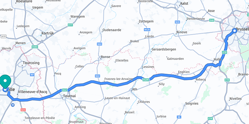
The AWS CLI can calculate driving directions between two locations, such as Brussels, Belgium, and Lille, France. The response includes a polyline for map rendering and a detailed list of driving directions.
Step 5: Display Driving Directions on a Map
Using the MapLibre library, developers can visualize routes on a map in web and mobile applications. This integration is supported by the Amazon Location Service Developer Guide, which provides detailed instructions for building applications that display routes.
Getting Started with Enhanced APIs
The new and updated APIs from Amazon Location Service offer a comprehensive suite of mapping and location data tools tailored to business needs. These tools enhance the development lifecycle by increasing agility and scalability for developers. To begin integrating these features, developers can explore the updated Amazon Location Service Developer Guide and make use of their preferred AWS SDKs for testing and implementation.
For further exploration and to try out these APIs, developers can visit the Amazon Location Service page or refer to the AWS documentation for detailed guidance. This expansion of Amazon Location Service is a significant step towards providing a robust, out-of-the-box solution for location-based applications, catering to a wide range of industries and use cases.
For more Information, Refer to this article.


