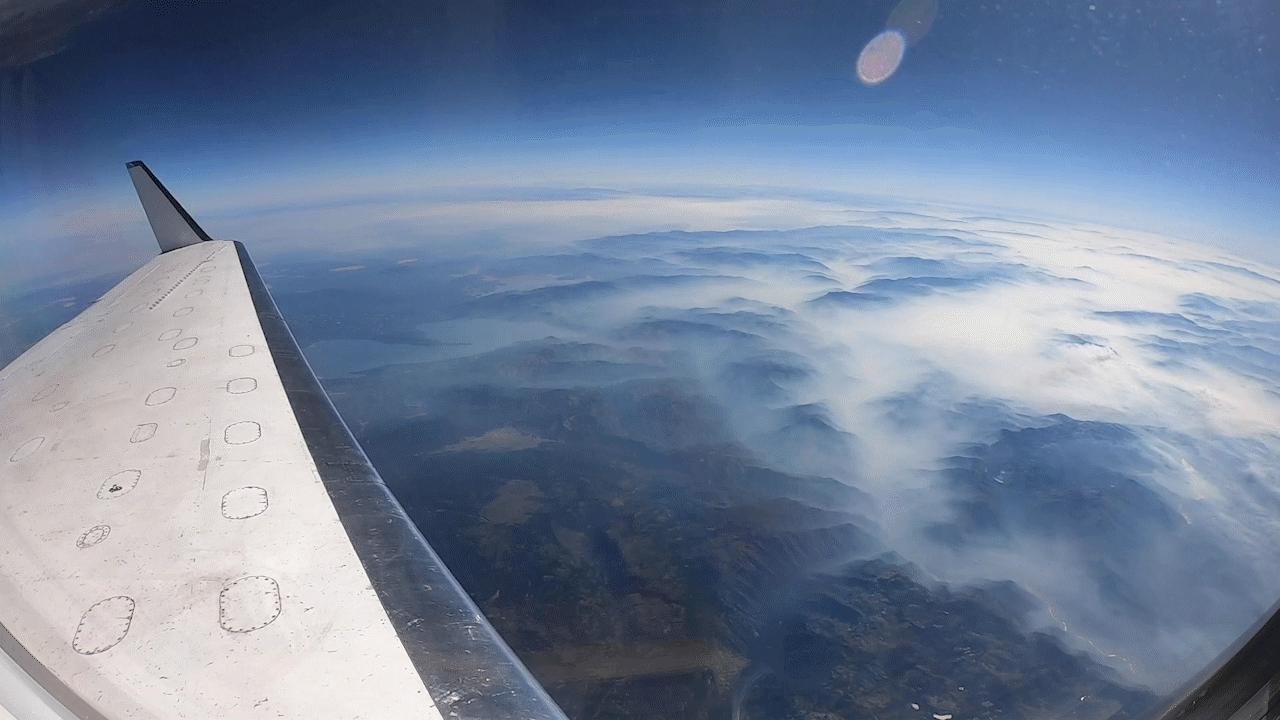
In a world increasingly impacted by climate change, natural disasters such as hurricanes, landslides, and wildfires are becoming more severe and frequent. To address these challenges, scientists require detailed data to assess the impact of such events and to predict future hazards effectively. One of the key tools in this mission is NASA’s C-20A aircraft, which is equipped with advanced instruments that facilitate a deeper understanding of the science behind these phenomena.
### The Role of NASA’s C-20A Aircraft
The C-20A aircraft, stationed at NASA’s Armstrong Flight Research Center in Edwards, California, is a modified version of the Gulfstream III business jet. Unlike its commercial counterpart, the C-20A is tailored for airborne science missions, making it an invaluable asset for Earth science research.
In October, the C-20A was deployed to survey areas devastated by Hurricane Milton. This hurricane, with winds reaching 120 miles per hour, struck Florida as a category 3 storm, unleashing torrential rainfall, lightning, and a series of tornadoes. Post-storm, the aircraft was equipped with the Uninhabited Aerial Vehicle Synthetic Aperture Radar (UAVSAR) to gather intricate data about the flood-affected regions.
“Our focus was particularly on inland river flooding near densely populated areas, gathering data that could aid in future disaster response and preparation,” explained Starr Ginn, the project manager for the C-20A aircraft. “The prompt response to support Hurricane Milton recovery efforts exemplified successful collaboration between science and aircraft teams.”
### UAVSAR: A Powerful Tool for Surface Analysis
Developed by NASA’s Jet Propulsion Laboratory (JPL) in Southern California, the UAVSAR employs a technique known as interferometry to detect minute changes in the Earth’s surface. Interferometry involves the intersection of multiple wavelengths to achieve precise measurements, enabling scientists to observe terrain changes or impacts before and after a significant natural event.
When mounted on an aircraft, radars like the UAVSAR offer more detailed data than satellite radars. “While satellite instruments might only capture data every one to two weeks, the UAVSAR fills in the gaps between satellite passes, calibrating ground-based instruments,” noted Ginn. “It collects data at a faster rate and with greater accuracy. By designing overlapping flights in multiple directions, we can detect more textures and movements on the Earth’s surface. This offers a significant advantage over the one-dimensional line-of-sight measurement provided by a single flight.”
### Investigating the Portuguese Bend Landslide
In addition to hurricane analysis, the C-20A team utilized the UAVSAR to study the Portuguese Bend landslide in Rancho Palos Verdes. This landslide originated over 11,000 years ago during the Pleistocene Epoch. Although it remained inactive for thousands of years, the landslide was reactivated in 1956 due to added weight from a road construction project at its summit. Recently, the landslide has been moving at an accelerated pace during dry seasons.
Scientists from NASA’s JPL, including Xiang Li, Alexander Handwerger, Gilles Peltzer, and Eric Fielding, have been examining the progression of this landslide using satellite-based instruments. “The high-resolution capability of UAVSAR is perfect for landslides since they have relatively small features,” said Ginn. “This allows us to understand the different characteristics of the landslide body.”
### Wildfire Analysis and Mitigation
The C-20A aircraft also plays a crucial role in wildfire studies. As part of the Fire and Smoke Model Evaluation Experiment (FASMEE), a multi-agency initiative led by the U.S. Department of Agriculture’s Forest Service Pacific Northwest Research Station, the C-20A conducted flights to analyze fire behavior and smoke production.
“The airborne perspective enables FASMEE researchers to gain a better understanding of fire behavior and smoke production,” commented Michael Falkowski, program manager for NASA’s Applied Sciences Wildland Fire program. “We hope this data will assist in mitigating fire risk, restoring degraded ecosystems, and protecting human communities from catastrophic fires.”
### The Future of Disaster Response and Prevention
Airborne data is instrumental in enhancing scientists’ and experts’ understanding of extreme phenomena on the ground. Researchers involved in the FASMEE experiment will utilize data collected from the UAVSAR to map forest composition and moisture, monitor areas affected by fire, and study fire progression.
“We can explore how fire managers can leverage airborne data to make informed decisions about fires,” added Jacquelyn Shuman, FireSense project scientist at NASA’s Ames Research Center in California’s Silicon Valley.
In conclusion, NASA’s C-20A aircraft, with its advanced scientific instruments, is pivotal in collecting precise data that improves our understanding of natural disasters. This data not only aids in immediate disaster response but also contributes significantly to future preparedness and prevention strategies. By leveraging such technology, scientists and researchers can better predict, respond to, and mitigate the impacts of natural disasters, ultimately safeguarding lives and communities from their devastating effects.
For more Information, Refer to this article.


![Samsung’s Innovation Sparks Progress in Science and Industry: Quantum Dots How Samsung’s Engineering Feat Became a Catalyst for Scientific and Industry Advancement [Interview on Real Quantum Dots Part 2.]](https://www.hawkdive.com/media/samsung-tvs-and-displays-samsung-quantum-dots-technology-qled-tvs-quantum-dots-experts-interview-par-218x150.jpeg)


