Cyclones Beyond the Tropics: A Closer Look at Mid- and High-Latitude Storms
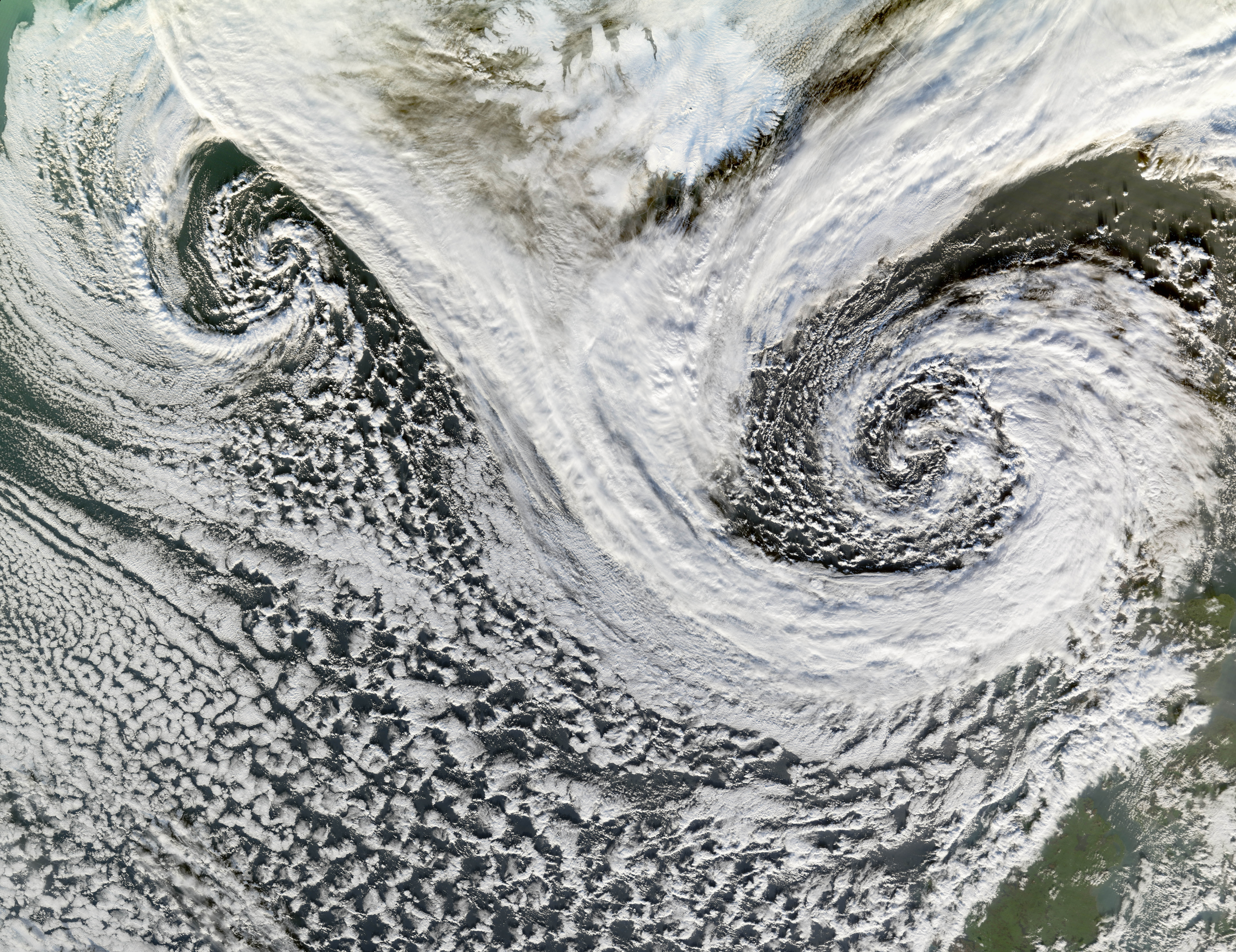
In a fascinating display of nature’s power, NASA’s Terra satellite recently captured an image that challenges our typical understanding of cyclones. The Moderate Resolution Imaging Spectroradiometer (MODIS), an advanced instrument aboard the satellite, photographed two cyclones near Iceland on November 20, 2006. This imagery provides a perfect opportunity to delve into the intriguing world of cyclones that form outside the tropics.
Understanding Cyclones
When we think of cyclones, our minds often drift to powerful storms spinning over warm, tropical oceans. However, cyclones are not exclusive to these regions. They can also develop in mid- and high-latitude areas, which are regions located between the tropics and the polar circles. These cyclones, often referred to as extratropical cyclones, play a crucial role in influencing the Earth’s weather patterns.
The Role of MODIS and Terra Satellite
The Terra satellite, a vital part of NASA’s Earth Observing System, is equipped with MODIS to collect data on various global dynamics, including atmospheric, oceanic, and terrestrial phenomena. The sensor’s ability to capture high-resolution images of Earth’s surface has made it an invaluable tool in monitoring environmental changes and natural disasters.
The image of the two cyclones near Iceland serves as a compelling reminder of the diverse capabilities of the Terra satellite. By observing these weather systems from space, scientists can gather crucial data that helps in understanding and predicting weather patterns across the globe.
Cyclone Formation at Mid- and High Latitudes
Cyclones at mid- and high latitudes form when different air masses collide. Typically, a cold air mass from the polar regions meets a warm air mass from the tropics. The interaction between these air masses creates a zone of low pressure, initiating the development of a cyclone. These extratropical cyclones are characterized by their spiraling wind patterns, similar to their tropical counterparts.
While tropical cyclones, such as hurricanes, derive their energy from warm ocean waters, extratropical cyclones are powered by temperature differences between air masses. This distinction is crucial in understanding how these weather systems develop and behave.
Commonality and Impact of Extratropical Cyclones
Extratropical cyclones are not rare occurrences. In fact, they are quite common and are instrumental in shaping the weather conditions in many parts of the world. These cyclones are responsible for much of the precipitation and wind patterns experienced in mid- and high-latitude regions. They can bring about significant weather events, such as heavy rain, snowstorms, and strong winds, influencing daily life and economic activities.
One of the reasons these cyclones are critical to monitor is their potential impact on human activities. Severe extratropical cyclones can disrupt transportation, affect agriculture, and even cause power outages. Understanding their behavior and predicting their paths can help mitigate these impacts.
The Importance of Satellite Imagery
Satellite imagery, like the one captured by MODIS, is essential for meteorologists and scientists in tracking and studying cyclone formation and movement. By analyzing these images, researchers can gain insights into the structure and dynamics of cyclones. This information is vital for improving weather forecasts and developing strategies to minimize the adverse effects of severe weather events.
Moreover, satellite data contributes to climate research by providing a long-term record of cyclone activity. This data helps scientists understand how climate change might be influencing the frequency and intensity of cyclones at different latitudes.
A Broader Perspective on Cyclone Research
The study of cyclones, both tropical and extratropical, is a dynamic field of research. By leveraging advanced technologies like MODIS, scientists can explore the complexities of these weather systems in greater detail. This research not only enhances our understanding of cyclones but also contributes to broader climate studies.
As climate change continues to influence global weather patterns, the importance of studying cyclones becomes even more pronounced. Changes in sea surface temperatures, atmospheric composition, and other environmental factors could potentially alter cyclone behavior. Continuous monitoring and research are necessary to adapt to these changes and develop effective mitigation strategies.
Conclusion
The image of the two cyclones near Iceland, captured by the MODIS instrument on NASA’s Terra satellite, serves as a powerful reminder of the complexity and variability of Earth’s weather systems. Cyclones, whether they form in the tropics or at higher latitudes, are integral components of the planet’s climate and weather dynamics.
As technology advances, our ability to monitor and understand these phenomena continues to grow. Satellite imagery and data collection play a pivotal role in this endeavor, providing valuable insights that can help us better prepare for and respond to the challenges posed by cyclones and other natural events.
For further reading and to explore more about the Terra satellite and MODIS, visit NASA’s official page on the Moderate Resolution Imaging Spectroradiometer here.
For more Information, Refer to this article.


