Fires Ravage Los Angeles County: A View from Space
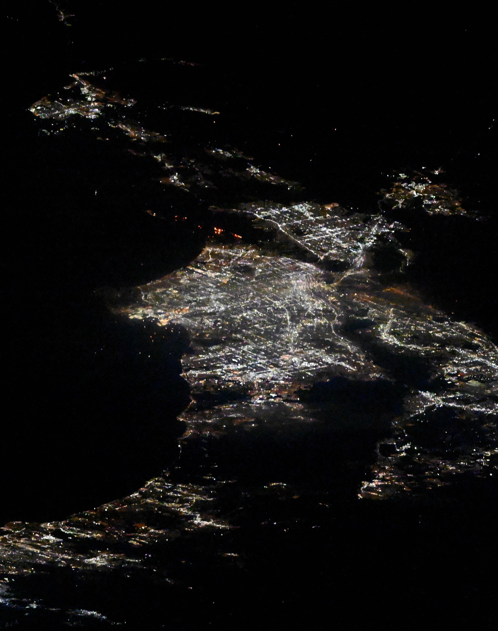
In early January 2025, a series of devastating fires erupted in the hills of Los Angeles County. These fires were fueled by an exceptionally dry landscape and powerful winds that reached speeds of up to 100 miles per hour. The magnitude and intensity of these fires caught the attention of many, including NASA astronaut Don Pettit, who captured striking images of the infernos from his unique vantage point aboard the International Space Station (ISS) on January 10, 2025.
From space, the scale of the destruction was alarmingly clear. The images shared by Pettit revealed vast areas engulfed in flames, painting a vivid picture of the disaster unfolding below. This perspective offered by the ISS serves as a stark reminder of how natural disasters can transform landscapes and impact communities in a profound way.
The Science Behind the Fires
The fires in Los Angeles County were primarily driven by a combination of environmental factors. The region had been experiencing a prolonged dry spell, which left vegetation parched and highly flammable. This condition, known as a dry landscape, significantly increases the likelihood of fires starting and spreading rapidly.
Moreover, the Santa Ana winds, notorious for their dry and warm characteristics, played a crucial role in fanning the flames. These winds, which are common in Southern California, can reach speeds of up to 100 miles per hour, providing the fires with the oxygen needed to grow and spread across the hills at an alarming rate.
The Role of Satellite Imagery in Monitoring Fires
The use of satellite imagery in monitoring and managing wildfires has become increasingly important. Satellites provide a bird’s-eye view of large areas, allowing scientists and emergency responders to track the movement and development of fires in real-time. This information is critical for coordinating firefighting efforts, assessing damage, and planning evacuations.
In the case of the Los Angeles fires, the images taken from the International Space Station offered invaluable insights. They provided a comprehensive overview of the affected areas, helping authorities understand the full scope of the disaster. Such imagery not only aids in immediate response efforts but also contributes to long-term studies on fire behavior and prevention strategies.
Impact on the Community
The fires in Los Angeles County had a profound impact on the local community. Many residents were forced to evacuate their homes, leaving behind their belongings and facing an uncertain future. The destruction of homes, infrastructure, and natural habitats also had significant economic and environmental repercussions.
In addition to the immediate physical damage, the fires contributed to air pollution, with smoke and ash affecting air quality across the region. This poses health risks, particularly for vulnerable populations such as the elderly, children, and those with pre-existing respiratory conditions.
Reactions and Responses
The severity of the fires prompted swift responses from local and state authorities. Firefighters from across California were deployed to battle the blazes, working tirelessly to protect lives and property. Their efforts were supported by aerial firefighting units, which used helicopters and planes to drop water and fire retardants on the flames.
Community organizations and volunteers also played a crucial role in supporting evacuees, providing shelter, food, and other necessities. The spirit of solidarity and cooperation was evident as people came together to support those affected by the disaster.
Looking Forward: Lessons and Preparedness
As the fires are brought under control and the recovery process begins, it is essential to reflect on the lessons learned and consider measures to enhance preparedness for future events. Climate change is expected to increase the frequency and intensity of wildfires, making it imperative for communities and authorities to adapt to these challenges.
Investing in fire-resistant infrastructure, improving early warning systems, and promoting public awareness about fire safety are key steps in mitigating the impact of future fires. Additionally, supporting scientific research and technological advancements in fire monitoring and management will play a crucial role in building resilience against such natural disasters.
For more information and to view the satellite imagery of the fires, visit the NASA Earth Observatory website.
Image credit: NASA/Don Pettit
In conclusion, the Los Angeles fires of January 2025 serve as a sobering reminder of the power of nature and the importance of preparedness in the face of environmental challenges. By leveraging technology, fostering community resilience, and prioritizing sustainability, we can better protect our communities and natural landscapes from the devastating effects of wildfires.
For more Information, Refer to this article.


