Unveiling the Greenland Tsunami: Insights from the SWOT Satellite
In September 2023, a remarkable event unfolded in Greenland, capturing the attention of scientists and researchers globally. A massive rockslide in the Dickson Fjord triggered a tsunami that caused a seismic rumble felt worldwide for an astonishing nine days. This natural phenomenon was meticulously captured by the international Surface Water and Ocean Topography (SWOT) satellite mission, a joint effort by NASA and France’s CNES (Centre National d’Études Spatiales).
The SWOT satellite’s mission is to survey Earth’s water bodies, providing detailed insights into the water surface elevation, which is crucial for understanding climate change and managing water resources. This particular event in Greenland provided an opportunity to showcase the satellite’s advanced capabilities in monitoring natural disasters.
The Rockslide and Resulting Tsunami
The event was set in motion when over 880 million cubic feet (approximately 25 million cubic meters) of rock and ice plummeted into the Dickson Fjord, a deep and narrow body of water located on Greenland’s eastern coast. With a depth of about 1,772 feet (540 meters) and a width of 1.7 miles (2.7 kilometers), the fjord’s steep walls, towering over 6,000 feet (1,830 meters), created a confined environment where the energy from the rockslide-induced tsunami had little room to dissipate.
The tsunami’s energy caused the water within the fjord to slosh back and forth, creating a unique wave pattern that repeated every 90 seconds. This oscillating motion persisted for nine days, generating tremors that were detected by seismic instruments located thousands of miles away.
SWOT’s Role in Monitoring the Tsunami
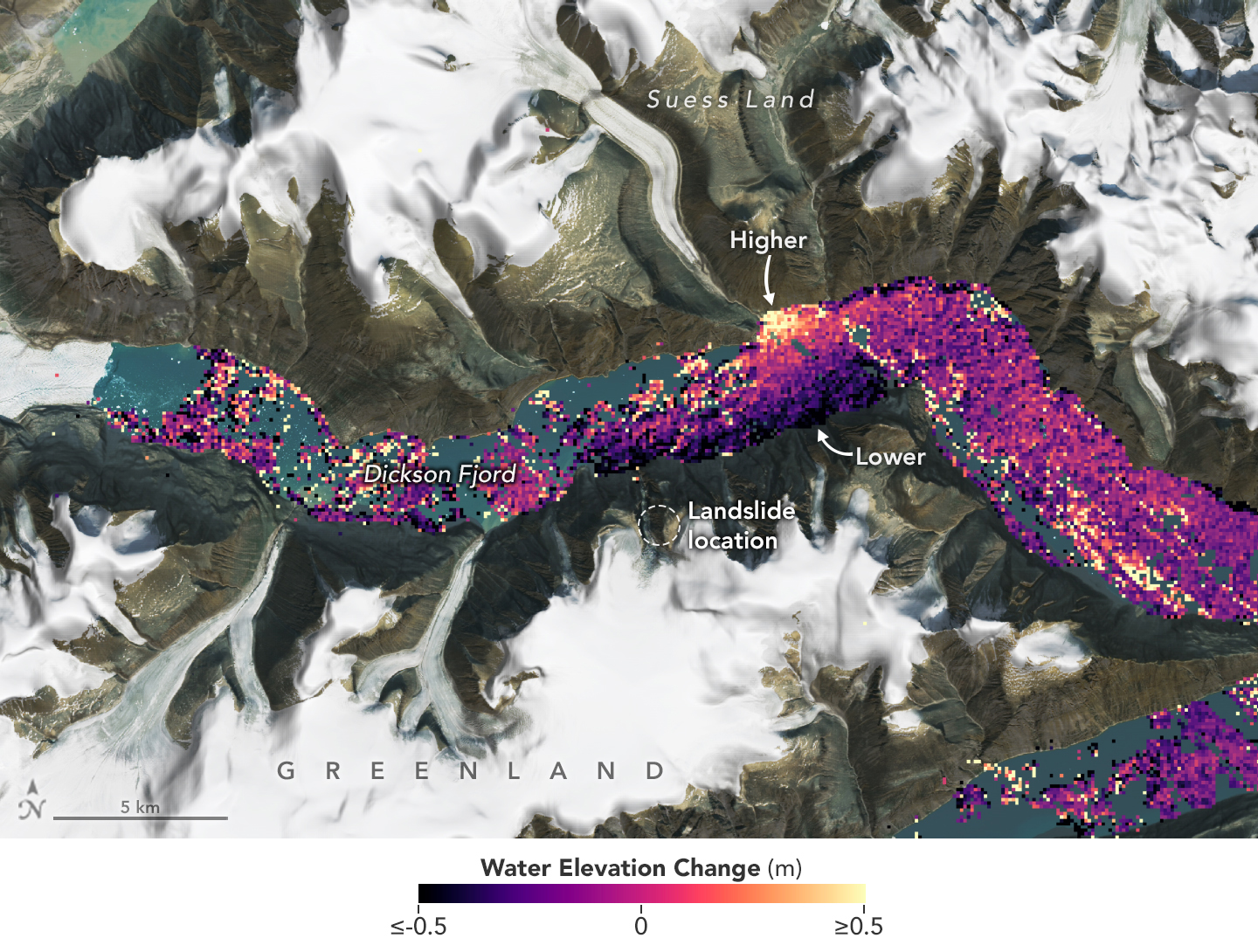
On September 17, 2023, just a day after the rockslide, the SWOT satellite passed over the Dickson Fjord, capturing crucial data about the water elevation changes caused by the tsunami. By comparing these measurements with baseline data collected on August 6, 2023, the scientists were able to visualize the changes in water levels within the fjord.
In the visual representation of this data, areas with higher water levels were depicted in red, while those with lower water levels appeared in blue. This analysis revealed that water levels along the north side of the fjord were elevated by as much as 4 feet (1.2 meters) compared to the south side. This information was critical in understanding the behavior and characteristics of the tsunami wave.
Technological Advancements: The Ka-band Radar Interferometer
The SWOT satellite is equipped with a sophisticated instrument known as the Ka-band Radar Interferometer (KaRIn), which allows it to measure the height of nearly all water surfaces on Earth, including oceans, lakes, reservoirs, and rivers. This technology is particularly valuable in monitoring and analyzing water bodies in remote or inaccessible regions.
According to Lee-Lueng Fu, the SWOT project scientist, the KaRIn instrument’s high resolution enabled the satellite to make precise observations even within the relatively narrow confines of the fjord. This level of detail is something that conventional altimeters, which typically have a larger footprint, cannot achieve.
Implications for Disaster Preparedness
Beyond its scientific contributions, the SWOT satellite’s ability to detect and monitor events like the Greenland tsunami has significant implications for disaster preparedness and risk reduction. By providing real-time data on water elevation changes, SWOT can help authorities anticipate and respond to natural disasters, potentially minimizing their impact on communities and ecosystems.
SWOT program scientist Nadya Vinogradova Shiffer emphasized the satellite’s potential to enhance hazard monitoring capabilities, thereby contributing to global efforts in disaster management and resilience building.
International Collaboration in Space Technology
The SWOT mission is a testament to the power of international collaboration in advancing space technology and scientific research. Jointly developed by NASA and CNES, with contributions from the Canadian Space Agency (CSA) and the UK Space Agency, the SWOT satellite represents a collective effort to deepen our understanding of Earth’s water systems.
NASA’s Jet Propulsion Laboratory, managed by Caltech, leads the U.S. component of the project. NASA was responsible for the development of the KaRIn instrument, a GPS science receiver, a laser retroreflector, and a two-beam microwave radiometer. The agency also provided the launch vehicle and managed the launch services through its Kennedy Space Center in Florida.
CNES, on the other hand, supplied the Doppler Orbitography and Radioposition Integrated by Satellite (DORIS) system, the dual frequency Poseidon altimeter, and the satellite platform. The UK Space Agency supported the development of the KaRIn radio-frequency subsystem, while CSA contributed the KaRIn high-power transmitter assembly.
Looking Ahead
Launched in December 2022 from Vandenberg Space Force Base in California, the SWOT satellite has now entered its operational phase. It continues to collect valuable data that will aid researchers in various fields, including climate science, hydrology, and oceanography.
The Greenland tsunami event serves as a powerful reminder of the dynamic nature of our planet and the importance of continuous monitoring and research. By leveraging advanced satellite technology, scientists can gain deeper insights into these phenomena, ultimately contributing to a more resilient and informed global society.
For those interested in learning more about the SWOT mission and its findings, additional information can be found on the SWOT website.
This event highlights not only the fascinating natural processes at work on our planet but also the critical role of technology and international cooperation in advancing our understanding of these processes. As we continue to harness the power of space technology, we can look forward to new discoveries that will shape our knowledge of Earth’s interconnected systems and help us address the challenges posed by a changing climate.
For more Information, Refer to this article.


