Tanager-1 Satellite: A New Era in Greenhouse Gas Detection
The recent advancements in satellite technology have taken a significant step forward with the Tanager-1 satellite, a project under the Carbon Mapper Coalition. This satellite, equipped with a sophisticated imaging spectrometer, has successfully identified methane and carbon dioxide plumes across various parts of the globe, marking a substantial achievement in environmental monitoring.
A Collaboration of Expertise
The Tanager-1 satellite is a collaborative effort that brings together expertise from NASA’s Jet Propulsion Laboratory (JPL) in Southern California and Planet Labs PBC. This collaboration aims to address the pressing issue of greenhouse gas emissions, which are significant contributors to climate change. The satellite officially took off from the Vandenberg Space Force Base in California on August 16, and since then, it has been diligently collecting and transmitting data back to Earth.
First Results: Methane and Carbon Dioxide Detections
The initial data from Tanager-1 is promising, highlighting its potential to transform our understanding of greenhouse gas emissions. The satellite has detected methane plumes in Pakistan and Texas, as well as a carbon dioxide plume in South Africa. These findings are crucial as they provide concrete evidence of emission sources, which can inform and guide emission reduction strategies.
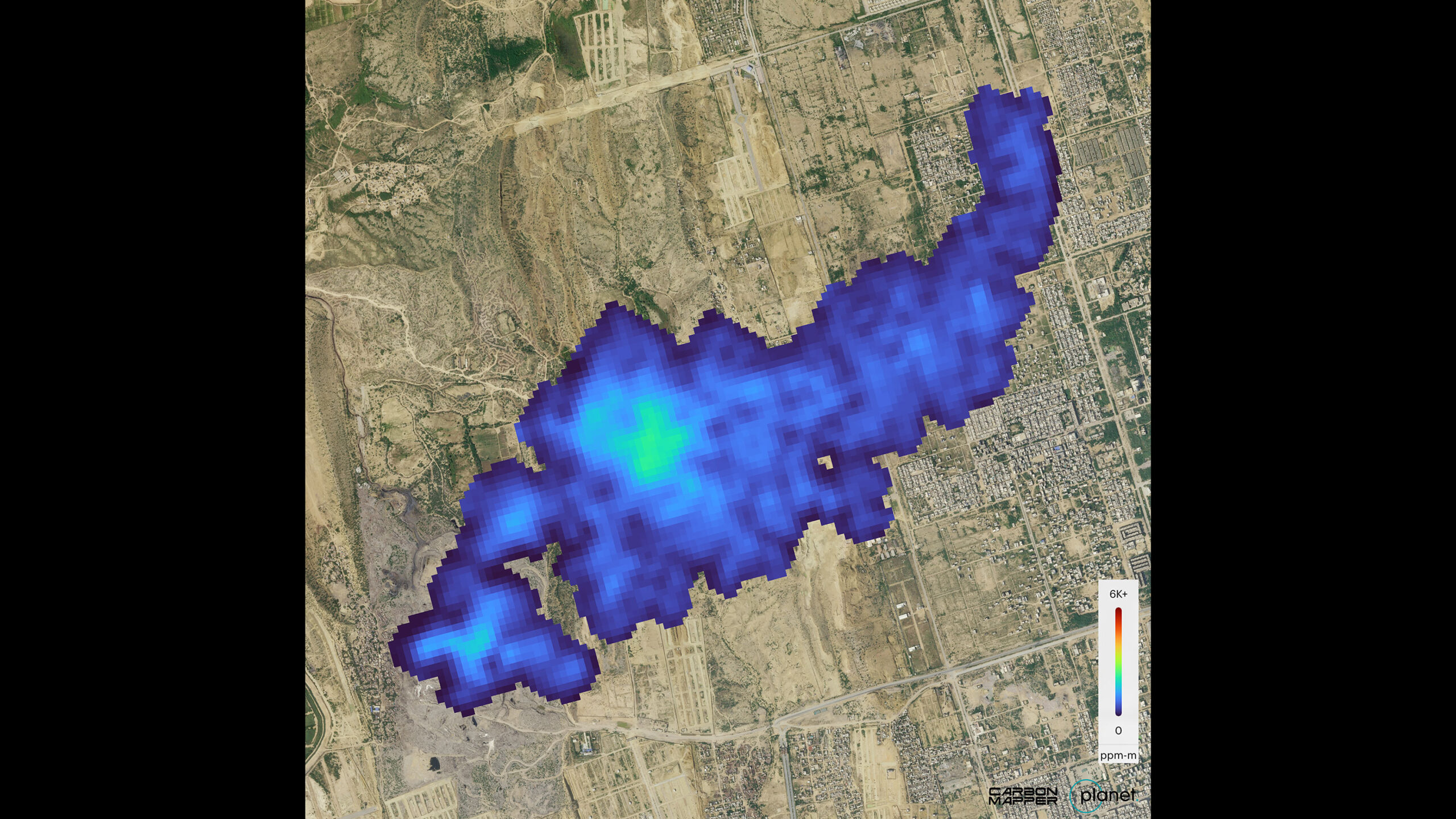
In Pakistan, the satellite captured a significant methane plume over Karachi on September 19. The plume, originating from a landfill, spans approximately 2.5 miles (4 kilometers). Preliminary estimates suggest that this source emits over 2,600 pounds (1,200 kilograms) of methane per hour. These findings underline the importance of addressing waste management issues to curb methane emissions.
Similarly, in South Africa, Tanager-1 detected a carbon dioxide plume over Kendal. This plume, stretching about 2 miles (3 kilometers), is associated with a coal-fired power plant. The estimated emissions rate is around 1.3 million pounds (600,000 kilograms) of carbon dioxide per hour, highlighting the significant environmental impact of coal-based energy production.
In Texas, the satellite identified a methane plume south of Midland in the Permian Basin, one of the world’s largest oilfields. The emission rate here is nearly 900 pounds (400 kilograms) of methane per hour. This discovery emphasizes the need for improved practices in the oil and gas industry to minimize methane leaks.
Technological Innovation: Imaging Spectrometer
The Tanager-1 satellite’s ability to detect these emissions is largely due to its advanced imaging spectrometer, which is a descendant of technology initially developed by JPL. Imaging spectrometers like this one can measure hundreds of wavelengths of light reflected from the Earth’s surface. Each chemical compound reflects and absorbs light in unique ways, creating a "spectral fingerprint" that researchers can identify to detect specific emissions.
This innovative technology traces its roots back to the 1980s when JPL pioneered the development of imaging spectrometers with the Airborne Visible/Infrared Imaging Spectrometer (AVIRIS). More recently, NASA deployed the Earth Surface Mineral Dust Source Investigation (EMIT) spectrometer on the International Space Station in 2022. Building on these advancements, Tanager-1’s spectrometer is designed to provide detailed, facility-level emissions data that is crucial for informed decision-making.
A Step Towards Global Monitoring
Once fully operational, Tanager-1 is expected to scan approximately 116,000 square miles (300,000 square kilometers) of the Earth’s surface daily. The data collected will be made publicly available through the Carbon Mapper data portal, ensuring transparency and enabling stakeholders worldwide to access vital information on greenhouse gas emissions.
The Mission of Carbon Mapper
Carbon Mapper, a nonprofit organization, plays a pivotal role in this initiative. Its mission is to bridge gaps in the current global ecosystem of methane and carbon dioxide monitoring systems. By delivering precise, timely, and accessible data at a facility scale, Carbon Mapper aims to empower science-based decision-making and prompt action.
The organization is at the forefront of developing a constellation of satellites, supported by a public-private partnership. This coalition includes Planet Labs PBC, JPL, the California Air Resources Board, Arizona State University, and RMI. Funding is provided by donors such as the High Tide Foundation, Bloomberg Philanthropies, and the Grantham Foundation for the Protection of the Environment.
The Importance of Greenhouse Gas Monitoring
The detection and measurement of greenhouse gases are crucial in the fight against climate change. Methane and carbon dioxide are two of the most significant greenhouse gases, contributing to global warming and climate instability. By pinpointing their sources, initiatives like Tanager-1 help in formulating targeted strategies to reduce emissions and mitigate their impact.
Methane is particularly potent, having a much higher heat-trapping capability than carbon dioxide over a short period. This makes its detection and management a priority. On the other hand, carbon dioxide, although less potent per molecule, remains in the atmosphere much longer, making its cumulative effect significant. Therefore, understanding its sources is equally critical.
The Road Ahead
The initial success of Tanager-1 is just the beginning. As the satellite continues to operate and gather data, it will enhance our understanding of greenhouse gas emissions and their sources. This information is invaluable in shaping policies and practices aimed at reducing emissions and combating climate change.
The data from Tanager-1 will not only inform scientists and policymakers but will also be accessible to the public, fostering a greater understanding of environmental issues. This transparency is vital in building trust and encouraging collective action towards a more sustainable future.
In conclusion, the Tanager-1 satellite represents a significant advancement in environmental monitoring technology. Its ability to detect and measure greenhouse gas emissions at a facility level provides critical insights that can drive meaningful action against climate change. As the satellite continues its mission, it holds the promise of transforming how we understand and address the pressing issue of greenhouse gas emissions on a global scale.
For further information and to explore the data collected by Tanager-1, readers are encouraged to visit the Carbon Mapper data portal at Carbon Mapper data portal.
For more Information, Refer to this article.


